
2015 Newsletter
- From the Chairman
- Rights of Way Local Forums – OFS Representation
- The Road Through the Woods
- OFS Annual Meal
- Chadlington Gates
- Fund Raising
- From the Archives
- Malvern Hills Weekend
- Lulworth
- How to Report Problems
- Become a Detective of Lost Paths
- Diversions, etc.
- The Jack Ibbott Memorial Walk
- Update of Isle of Wight Walk
Update of Isle of Wight Walk
As some of you may remember, Barry and I did a successive annual walk of 11miles on the West side of the Isle of Wight. The first one was in 2008 when we had 14 members on the walk.
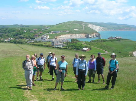 Photo: Helen Burlingham
This July we reccied the route again, starting as usual on the, now much bigger, ferry from Lymington which, as we were so high, gave us a much better view of the castle. We could see the Tudor walls, windows, rooms and courtyards, as well as the chimneys and canon. The two new ferries are bigger and better, but now have a less frequent service- once an hour only at peak times.
Having disembarked, we walked through Yarmouth, then along the Yar estuary, past the mill, to the Freshwater way, formerly a railway track, a nature lovers’ paradise being full of butterflies, such as the marble white, wild flowers and birds. Trees on the way provide shelter from the sun, and several stiles have been replaced, by the IOW Ramblers, with kissing gates; much more convenient.
After 3.5 miles we reached Freshwater Bay, which used to be a nice bathing beach, but is now covered with seaweed. The National Trust has purchased a farmer’s field next to the cliffs, so now, instead of a steep climb close to the side of the cliff, we can walk across the wide field to a gate to get on to Tennyson Down. Despite the strong wind, I could still hear the skylarks singing, and saw them flying high above.
From the high points of these cliffs, one sees the splendid views of both the IOW and the mainland coast with the Fawley oil refinery, and Hurst castle, in the distance. At the peak is the monument to Tennyson. The inscription reads:
IN MEMORY OF ALFRED LORD TENNYSON THIS CROSS IS RAISED A BEACON TO SAILORS BY THE PEOPLE OF FRESHWATER & OTHER FRIENDS IN ENGLAND AND AMERICA
and a plaque with it, which was put up recently:
...Take it and come to the Isle of Wight: Where, far from the noise of smoke and town, I watch the twilight falling brown All around a careless ordered garden, Close to the ridge of a noble down.
The wind abated on the path down to Totland Bay and we noticed bright pink pyramidal orchids, the national flower of the island, lining our way. Nearer the bay we passed a wedding at an RC church, a pub, and two guesthouses which are now closed.
When we arrived at the closed café in front of the pier, we saw the landslide into the sea, which had destroyed the coastal path to Colwell Bay in December 2012. Windy Totland looked like a “ghost resort” - no holiday-makers, no coastal path, thronged with locals, holiday-makers and ramblers; it’s now fenced off with a large notice, “Footpath closed- Do not Enter”.
Totland council will spend £200,000 on a “make do and mend” option to prevent further damage to the wall which will be finished at the end of September this year. A new pedestrian route between Totland and Colwell Bays will open. Natural England has approved the scheme: “It is not a full repair though, but will minimise further damage. This is the most realistic option given the council’s severe financial constraints”.
It will be a great improvement on the present coastal path, which is narrow and little more than a tree-lined passage. We crossed Colwell beach- metal steps missing - and continued onwards through the wood, and back to Yarmouth.
We hope to lead another walk like this next summer. Hope you will come!