
2015 Newsletter
- From the Chairman
- Rights of Way Local Forums – OFS Representation
- The Road Through the Woods
- OFS Annual Meal
- Chadlington Gates
- Fund Raising
- From the Archives
- Malvern Hills Weekend
- Lulworth
- How to Report Problems
- Become a Detective of Lost Paths
- Diversions, etc.
- The Jack Ibbott Memorial Walk
- Update of Isle of Wight Walk
From the Chairman
We are fortunate to live at a time when we can enjoy the 1700 miles of Public Rights of Way in Oxfordshire. The largest part of the path network would have developed during the medieval and post-medieval period when country folk walked from hamlet to village and to the emerging market towns. With the dissolution of the great monasteries and the dispersal of their huge land holdings, the open fields were enclosed, and in the enclosure awards that were made, parish by parish, many of these footpaths were identified on enclosure maps and designated as public rights of way. They form the backbone of today’s 21st century path network. Further enclosures were made during the 17th and 18th centuries.
You can find enclosure awards and maps in the County Records Offices. In the article ‘Become a detective of lost paths’; I ask members to consider spending a day or two in the Records Office to see if there are any ‘lost’ paths in the parish where they live. Paths not identified and listed by 2026 will be lost forever. The clock is ticking!
The Countryside Access Team carries the responsibility for managing and preserving Oxfordshire’s path network. We, the OFS, have the right to send two representatives to each of the four Local Forums who meet twice a year and I believe it is very important to ensure that the Society is represented at these meetings. We all have an obligation to support the work of the County Field Officers and I know that they, in their turn, welcome the encouragement that we, the users of the network, can give them. The time commitment that a member would give is very small; perhaps a total of 6 hours in the year.
The coming year of 2016 is the 90th anniversary of the founding of our society. To mark the event, the Committee has concentrated upon celebrating the immense contribution that Colonel Wytton Perowne d’Arcy Dalton made to the Society throughout his lifetime. D’Arcy Dalton had the inspiration to initiate and produce a map, based on the Ordnance Survey at a scale of 2 miles to the inch, of some 144 square miles of countryside centred on the City of Oxford. On it are shown all the footpaths and bridleways that the Society then believed were Public Rights of Way. (PRoW) These footpaths had been walked by the Society and reference was also made to Enclosure Award maps. The map was published in 1933, some 15 years before the publication of what could be considered as its successor: the Definitive Map.
After the Second World War d’Arcy Dalton attended many enquiries as part of the process of compiling the Definitive Map that would, for the first time, give legal protection to the PRoW network. He was successful in claiming 135 paths identified and submitted by the OFS, but which the County Council had initially rejected. He also attended hearings where landowners were objecting to paths being claimed by the parish councils. At 57 hearings, d’Arcy Dalton was successful in overcoming every single objection. He was surely the champion and defender of Oxfordshire’s footpaths.
If this was not enough, d’Arcy Dalton ensured the financial strength of the Society by promoting, (when he was Chairman of the Society), - in partnership with the Oxford branch of the CPRE which he had founded - a series of sponsored walks during the years 1968 to 1979. These attracted large support from school pupils in Oxford, and this financial contribution formed the basis of the capital funds of the OFS, now totalling some £33,000 and enabling the Society to provide improvements to the entire path network within the county.
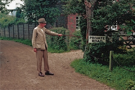 Photo: Alun Jones
It is appropriate, therefore, to mark our 90th anniversary by submitting a proposal for a Blue Plaque to be placed on the house in Great Milton where for many years d’Arcy Dalton lived.
We have written to the BBC to suggest that an OFS walk be included in Clare Balding’s series, ‘Ramblings’, on Radio 4, as part of the 2016 series. The proposed walk would follow the most southerly section of the d’Arcy Dalton Way, from Longcot to Wayland’s Smithy.